Eritrea
2007 Schools Wikipedia Selection. Related subjects: African Countries; Countries
| Hagere Ertra ሃገረ ኤርትራ دولة إرتريا State of Eritrea |
|||||
|
|||||
| Anthem: Ertra, Ertra, Ertra | |||||
| Capital (and largest city) |
Asmara |
||||
| Official languages | none1 | ||||
|---|---|---|---|---|---|
| Government | Transitional government | ||||
| - President | Isaias Afewerki | ||||
| Independence | from Ethiopia | ||||
| - De facto | May 29, 1991 | ||||
| - De jure | May 24, 1993 | ||||
| Area | |||||
| - Total | 117,600 km² ( 100th) 45,405 sq mi |
||||
| - Water (%) | negligible | ||||
| Population | |||||
| - July 2005 estimate | 4,401,000 ( 118th) | ||||
| - 2002 census | 4,298,269 | ||||
| - Density | 37/km² ( 165th) 96/sq mi |
||||
| GDP ( PPP) | 2005 estimate | ||||
| - Total | $3.977 billion ( 156th) | ||||
| - Per capita | $858 ( 172nd) | ||||
| HDI (2005) | |||||
| Currency | Nakfa ( ERN) |
||||
| Time zone | EAT ( UTC+3) | ||||
| - Summer ( DST) | not observed ( UTC+3) | ||||
| Internet TLD | .er | ||||
| Calling code | +291 | ||||
| 1 Working languages: Tigrinya, Arabic and English | |||||
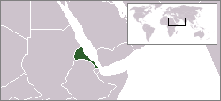
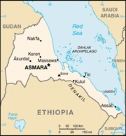
Eritrea ( Ge'ez ኤርትራ ʾĒrtrā) is a country in northern East Africa bordered by Sudan in the west, Ethiopia in the south, and Djibouti in the southeast. The east and northeast of the country have an extensive coastline on the Red Sea, directly across from Saudi Arabia and Yemen. The Dahlak Archipelago and several of the Hanish Islands are part of Eritrea.
Eritrea was consolidated into a colony by the Italian government on January 1, 1890. The modern state of Eritrea gained its independence from Ethiopia following a thirty year war which lasted from 1961 to 1991. Eritrea's constitution adopted in 1997 stipulates that the state is a presidential republic with a unicameral parliamentary democracy. But the constitution was never ratified and since the outbreak of hostilities with Ethiopia in May of 1998, the country is under a de-facto (undeclared) state of emegency ruled by presidential decree.
Eritrea is a multilingual and multicultural country with two dominant religions and nine ethnic groups. The country has no official language, but it has three working languages: Tigrinya, Arabic, and English.
History
The first detailed written source of the territory currently known as Eritrea is the chronicled expedition launched by the Ancient Egyptian Pharao Hatshepsut to the fabled Punt (or "Ta Netjeru," meaning land of the Gods) in the 15th century BC in search of incense. Although, the oldest Egyptian expedition to Punt was made already in the 25th century BC under Pharao Suhure. The geographical description of the missions to Punt roughly correspond to the southern west coast of the Red Sea.
The modern name Eritrea was first employed by the Italian colonialists in the late 19th century. It is the Italian form of the Greek name ΕΡΥΘΡΑΙΑ (Erythraîa; see also List of traditional Greek place names), which derives from the Greek term for the Red Sea (Ἐρυθρὰ Θάλασσα).
Pre History
In 1998 the cranium of a hominid, an intermediate between a Homo erectus and an archaic Homo Sapien, was found in Buya, Eritrea by American scientists. The cranium was dated to over 1 million years old (the oldest of its kind), providing a link between hominids and the earliest humans. Furthermore, the Eritrean Research Project Team, composed of Eritrean, Canadian, American, Dutch, and French scientists, discovered in 1999 a site with stone and obsidian tools dated to over 125 000 years old (from the paleolithic era) near the Bay of Zula south of Massawa along the Red Sea coast. The tools are believed to have been used by early humans to harvest marine resources like clams and oysters. Epipaleolithic or mesolithic remains in the form of cave paintings in central and northern Eritrea attest to the early settlement of hunter-gatherers in this region.
A US paleontologist says that the fossil of a pig-sized creature found in East Africa represents the missing link between ancient and modern elephants. The dating of the new fossil, discovered in Eritrea, to 27 million years ago also pushes the origins of elephants and mastodons 5 million years further into the past than previous records, University of Michigan paleontologist William Sanders said.
The findings by an international team that included Sanders suggest that mastodons and the ancestors of modern elephants originated in Africa, in contrast to mammals such as rhinos that had their origins in Europe and Asia and migrated into Africa. "In age and anatomy the newly discovered fossil is exactly the sort of intermediate evolutionists would expect to bridge the gap between archaic and advanced proboscideans," Sanders said.
In addition to Sanders, the research team included scientists from the University of Asmara in Eritrea; Franklin and Marshall College in Lancaster, PA, USA; the Eritrean ministry of mines and energy; Global Resources in Asmara, Eritrea; the Museum National d'Histoire Naturelle in Paris; the Elephant Research Foundation; the National Museum of Eritrea; and Deutsches Primatenzentrum in Gottingen, Germany.
Early History
The earliest evidence of agricultural settlement, urbanism, trade and agriculture is found in the region inhabited by people dating back to 3500 to 2500 BC in the archaeological sites called the Gash group. Based on the archaeological evidence, there seems to have been a connection between the peoples of the Gash group and the civilizations of the Nile Valley namely Ancient Egypt and Nubia. Ancient Egyptian sources also give references to cities and trading posts along the southwestern Red Sea coast, roughly corresponding to modern day Eritrea, calling this the land of Punt famed for its incense. An expedition to this very land was launched by the female pharao Hatshepsut from the 15th century BC and was chronicled in detail.
In the highlands, in one of the capital city Asmara's suburbs Sembel at the mouth of the river Anseba, another site was found from the 9th century BC of another agricultural and urban settlement which traded both with the Sabeans across the Red Sea and with the civilizations of the Nile Valley further west along caravan routes that followed the Anseba River. Around this time, several cities with a high amount of Sabean remains (inscriptions, artifacts, monuments, architecture etc) seem to emerge in the central highlands and along the central coast including one called Saba. Some are undoubtedly built on top of older sites.
Around the 8th century BC, a kingdom known as D'mt was established in what is today northern Ethiopia and Eritrea, with its capital at Yeha in northern Ethiopia and which had extensive relations with the Sabeans in present day Yemen across the Red Sea. After D`mt's decline around the 5th century BC, the state of Aksum arose in the northern Abyssinian plateau. It grew during the 4th century BC and came into prominence during the first century AD, minting its own coins by the 3rd century, converting in the 4th century to Christianity, as the second official Christian state (after Armenia) and the first country to feature the cross on its coins. According to Mani, it grew to be one of the four greatest civilizations in the world, on a par with China, Persia, and Rome. In the 7th century AD; with the advent of Islam across the Red Sea in Arabia, Aksum's trade and power on the Red Sea began to decline and the centre moved farther inland to the Ethiopian highlands of what is today Ethiopia and the state was eventually defeated by Islamic as well as other internal forces circa 850 or 950 AD
Medieval History
During the medieval period, the area which we now call Eritrea was the site of several states as well as tribal and clan lands. Between the 8th and 13th century, northern and western Eritrea had largely come under the domination of the Beja, an Islamic, Cushitic people from northeastern Sudan. They formed five independent kingdoms known as: Naqis, Baqlin, Bazin, Jarin and Qata. The Beja brought Islam to large parts of Eritrea and connected the region to the greater Islamic world dominated by the Ummayad Caliphate, followed by the Abbasid (and Mamluk) and later the Ottoman Empire. The Ummayads were already in direct possession of small stretches of the Eritrean coastline and the Dahlak archipelago by the 8th century. The Beja imposed themselves as rulers but did not impose their cushitic language or culture on their subjects but rather adopted the local Ge'ez based language. This language evolved over time into the Tigre language which to this day is the lingua franca of the predominantly Muslim lowlands and northern coast of Eritrea. Later, in the 15th and 16th centuries, nothern Eritrea and its coastline were taken over completely by the Ottomans who were to remain there for over 300 years and govern it from the port of Massawa. Meanwhile, the central highlands and adjacent coastline became the site of a Christian Kingdom called Midre Bahri or Midre Bahr meaning sea-land in Tigrinya and Tigre respectively, and ruled by the Bahr Negash or Bahr negus (meaning king of the sea) that was loosely affiliated with the Abyssinian kingdoms of the south (but at times also became involved in conflict with them in alliance with the Ottomans). The domain of the kingdom was for most of its history restricted to north of the perennial river Mareb and which still serves as a natural boundary between Eritrea and Ethiopia today. The other Abyssinian kingdoms south of the river therefor commonly referred to Midre Bahri as Mareb Mellash meaning 'beyond Mareb' (in the Amharic language of the Amhara who had come to dominate Abyssinia since the 13th century). The feudal authority of the Bahr Negash later waned and was replaced by a Republic known as Hamasien, which was based on a land-owning peasantry (citizenry) in the central highlands who ruled by elders councils or shimagile and maintained it's entire young and able male population as a standing army. The southern coastline meanwhile was populated by the Afar and Saho speaking Islamic chiefdoms or clan lands which by the 16th century had evolved into the centralized Adal sultanate (along with territories currently in eastern Ethiopia, Djibouti and Northern Somalia).
An Ottoman invading force under Suleiman I conquered Massawa in 1577, building what is now considered the 'old town' of Massawa on Batsi island. They also conquered the towns of Hergigo, and Debarwa, the capital city of the contemporary Bahr negus (ruler), Yeshaq. Suleiman's forces fought as far south as southeastern Tigray before being repulsed. Yeshaq was able to retake much of what the Ottomans captured with Abyssinian (Ethiopian) assistance, but he later twice revolted against the Emperor of Abyssinia with Ottoman support in an attempt to take the Abyssinian throne. By 1578, all revolts had ended, leaving the Ottomans in control of the important ports of Massawa and Hergigo and their environs, and leaving the province of Habesh to Beja Na'ibs (deputies). The Ottomans maintained their dominion over the northern coastal areas for nearly 300 years. Their possessions were left to their Egyptian heirs in 1865 and were taken over by the Italians in 1885.
Colonial era
An Italian Roman Catholic missionary and explorer by the name of Giuseppe Sapetto purchased the port of Assab from the Afar Sultanate on behalf of a Genovese (Italian) Shipping Company called Rubattino in 1869. This happened in the same year as the opening of the Suez Canal. In the ongoing Scramble for Africa, Italy as one of the European colonial powers began vying for a possession along the strategic coast of what was to become the world's busiest shipping lane. With the approval of the Italian parliament and King Umberto I of Italy (later succeeded by his son Victor Emmanuel III), the government of Italy bought the Rubattino Company's holdings and expanded its possessions northwards along the Red Sea coast towards and beyond Massawa, encroaching on and quickly expelling previously 'Egyptian' possessions. The Italians met with stiffer resistance in the Eritrean highlands from the army of the Abyssinian Emperor Yohannes IV that also wanted a piece of these lands and an outlet to the sea. Nevertheless the Italians repulsed both Egyptians and Abyssinians and consolidated their possessions into one colony, henceforth known as Eritrea, territory of Italy as of New Years Day of 1890.
The Italians remained the colonial power in Eritrea until they were defeated by Allied forces in World War II (1941), and Eritrea became a British protectorate. After the war, the United Nations conducted a lengthy inquiry, including a faulty referendum in which only the male "elders" (shimagile) of the Eritrean communities participated, in order to find out the wishes of the Eritrean people. During this time, those under Imperial Ethiopia's influence (who wanted unity with Ethiopia) and those who wanted Eritrea's independence, lobbied the great powers and the U.N. extensively. Imperial Ethiopia itself meddled immensely in the process, through bribing certain influential officials, intimidating others and most importantly by attempting to sow discord between Eritrean Muslims and Christians through its primary instrument: the Orthodox Church, which was used to herald Ethiopia as a bastion of Christianity, a haven and motherland of Christians and to spread a fear among Eritrean Christians that an independent Eritrea would inevitably succumb to Islamic rule. Moreover voting church members who did not vote for unity with Ethiopia as well as clergy who did not comply with the mission of the church were excommunicated or threatened with such by the Orthodox Church. The superpowers were also involved in a wrestle for a stake in the Eritrean question. The communist bloc along with most non-aligned independent third world countries favored Eritrean independence. The western powers Britain, France and the United States on the other hand already had Imperial Ethiopia as a close ally in line with western interests in the region and favored Eritrea being united with Ethiopia, rather than risk an independent Eritrea becoming a communist anti-western state. John Foster Dulles, the secretary of state of the United States at the time uttered the famous words:
"From the point of view of justice, the opinions of the Eritrean people must receive consideration. Nevertheless, the strategic interests of the United States in the Red Sea Basin and considerations of security and world peace make it necessary that the country (Eritrea) has to be linked with our ally, Ethiopia", John Foster Dulles in 1952.
Eventually a compromise was reached under which the former Italian colony was to be federated with Ethiopia. Eritrea would have its own parliament and administration, and would be represented in what had been the Ethiopian parliament and was now the federal parliament. The Emperor of Ethiopia predictably dissolved all semblance of the Federation by shutting down the parliament and declaring Eritrea the 14th province of Ethiopia in 1961. This led to the 30 year long Eritrean Struggle for Independence.
Struggle for independence
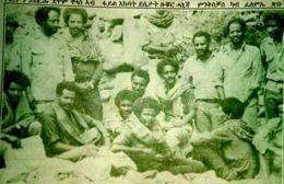
Eritreans formed the Eritrean Liberation Front (ELF) and rebelled. The rebel movement was initially dominated by the ELF but became rivaled by the Eritrean People's Liberation Front in the 1970s. The ELF was a conservative grass roots movement dominated by Muslim lowlanders, and thus received backing from Arab governments, whereas the EPLF professed Marxism and was supported by a growing Eritrean Diaspora. The ELF was eventually overshadowed and eliminated by the EPLF. The struggle for independence neared victory in the mid-1970s but suffered reverses when the Derg, a Marxist military junta, came to power in Ethiopia with backing from the Soviet Union and other countries. Nevertheless, Eritrean resistance continued and the numbers of the EPLF swelled as did that of Ethiopian resistance movements with which the EPLF struck alliances to overthrow the communist Ethiopian regime.
Independent era
The struggle for independence ended in 1991, when the EPLF expelled the Ethiopian Army from Eritrea and had also joined forces with Ethiopian resistance movements to overthrow the Derg regime which fell the same year. Two years later, a referendum was held supervised by the UN mission UNOVER, with universal suffrage and conducted both in and outside Eritrea (among Eritrean communities in the diaspora), on whether Eritreans wanted independence or unity with Ethiopia. Over 99% of the Eritrean people voted for independence which was declared on May 24 1993. The leader of the EPLF, Isaias Afewerki, became Eritrea's first Provisional President, and the Eritrean People's Liberation Front (later renamed the People's Front for Democracy and Justice, or PFDJ) created a government.
In 1998, a border war with Ethiopia over the town of Badme resulted in the deaths of thousands of Eritrean soldiers (19,000, according to the government; 20-50,000 by some estimates), massive population displacement, reduced economic development, and a severe land mine problem. During and after the war, the Ethiopian Government expelled Eritreans and those of Eritrean heritage from Ethiopia after confiscating their wealth and properties. The Eritrean-Ethiopian War ended in 2000 with a negotiated agreement known as the Algiers Agreement, which assigned an independent, UN-associated boundary commission known as the Eritrea-Ethiopia Boundary Commission (EEBC), whose task was to clearly identify the border between the two countries. The EEBC issued a final border ruling in April 2002 and awarded Badme to Eritrea. However, Ethiopia has not withdrawn all its troops from the town, which has led to fears for another war.
Administrative divisions
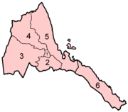
Eritrea is divided into 6 regions (or zobas) and subdivided into approximately 55 districts or sub-zobas. The geographical extent of the regions is based on their respective hydrological properties. This is due to a dual intent on the part of the Eritrean government, to provide each administration with sufficient control over its agricultural capacity and eliminate historical intra-regional conflicts.
The regions are included followed by the sub-region:
| Map location | Region (ዞባ) | Sub-region (ንኡስ ዞባ) |
| 1 | Central (ዞባ ማእከል) (المنطقة المركزية) |
Berikh, Ghala Nefhi, North Eastern, Serejaka, South Eastern, South Western |
|---|---|---|
| 2 | Southern (ዞባ ደቡብ) (المنطقة الجنوبية) |
Adi Keyh, Adi Quala, Areza, Debarwa, Dekemhare, Kudo Be'ur, Mai-Mne, Mendefera, Segeneiti, Senafe, Tserona |
| 3 | Gash-Barka (ዞባ ጋሽ ባርካ) (منطقة القاش وبركا) |
Agordat, Barentu, Dghe, Forto, Gogne, Haykota, Logo Anseba, Mensura, Mogolo, Molki, Omhajer (Guluj), Shambuko, Tesseney, Upper Gash |
| 4 | Anseba (ዞባ ዓንሰባ) (منطقة عنسبا) |
Adi Tekelezan, Asmat, Elabered, Geleb, Hagaz, Halhal, Habero, Keren City, Kerkebet, Sela |
| 5 | Northern Red Sea (ዞባ ሰሜናዊ ቀይሕ ባሕሪ) (منطقة البحر الأحمر الشمال) |
Afabet, Dahlak, Ghelalo, Foro, Ghinda, Karura, Massawa, Nakfa, She'eb |
| 6 | Southern Red Sea (ዞባ ደቡባዊ ቀይሕ ባሕሪ) (منطقة البحر الأحمر الجنوب) |
Are'eta, Central Dankalia, Southern Dankalia |
Politics and government
The National Assembly of 150 seats, formed in 1993 shortly after independence, elected the current president, Isaias Afewerki. National elections have been periodically scheduled and canceled. Independent local sources of political information on Eritrean domestic politics are scarce; in September 2001 the government closed down all of the nation's privately owned print media, and outspoken critics of the government have been arrested and held without trial, according to various international observers, including Human Rights Watch and Amnesty International. In 2004 the U.S. State Department declared Eritrea a Country of Particular Concern (CPC) for its alleged record of religious persecution (see below).
National elections
Eritrean National elections were set for 1997 and then postponed until 2001, it was then decided that because 20% of Eritrea's land was under occupation that elections would be postponed until the resolution of the conflict with Ethiopia. However, local elections have continued in Eritrea. The most recent round of local government elections were held in May 2003. On further elections, the President's Chief of Staff, Yemane Ghebremeskel said,
| The electoral commission is handling these elections this time round so that may be the new element in this process. The national assembly has also mandated the electoral commission to set the date for national elections, so whenever the electoral commission sets the date there will be national elections. It's not dependent on regional elections, although that might be a very helpful process. Multipartyism, in general principle yes, it is there but the law on political parties has to be approved by the national assembly. It was not approved the last time. The view from the beginning was that you don't necessarily need a party law to hold national elections. You can have national elections and the party law can be adopted at any time. So in terms of commitment it's very clear, in terms of the process it has its own pace, its own characteristics. |
Foreign relations
Eritrea is a member in good standing of the African Union (AU), the successor of the Organization of African Unity (OAU). But it has withdrawn its representative to the AU in protest of the AU's lack of leadership in facilitating the implementation of a binding border decision demarcating the border between Eritrea and Ethiopia. Eritrea's relationship with the United States is complicated. Although the two nations have a close working relationship regarding the on-going war on terror, there has been a growing tension in other areas. Eritrea's relationship with Italy and the EU has become equally strained in many areas in the last three years.
Within the region, Eritrea's relations with Ethiopia turned from that of close alliance to a deadly rivalry that lead to a war from May, 1998 to June 2000 in which 19,000 Eritreans were killed.
External issues include an undemarcated border with Sudan, a war with Yemen over the Hanish Islands in 1996, and a recent border conflict with Ethiopia.
The undemarcated border with Sudan poses a problem for Eritrean external relations. After a high-level delegation to Sudan from the Eritrean Ministry of Foreign Affairs ties are being normalized. While normalization of ties continues, Eritrea has been recognized as a broker for peace between the separate factions of the Sudanese civil war. "It is known that Eritrea played a role in bringing about the peace agreement [between the Southern Sudanese and Government]," while the Sudanese Government and Eastern Front rebels have requested Eritrea to mediate peace talks.
A dispute with Yemen over the Hanish Islands in 1996 resulted in a brief war. As part of an agreement to cease hostilities the two nations agreed to refer the issue to the Permanent Court of Arbitration at the Hague. At the conclusion of the proceedings, both nations acquiesced to the decision. Since 1996 both governments have remained wary of one another but relations are relatively normal.
The undemarcated border with Ethiopia is the primary external issue facing Eritrea. This led to a long and bloody border war between 1998 and 2000. As a result, the United Nations Mission in Ethiopia and Eritrea ( UNMEE) is occupying a 25 kilometres by 900 kilometres area on the border to help stabilize the region. Disagreements following the war have resulted in stalemate punctuated by periods of elevated tension and renewed threats of war. Central to the continuation of the stalemate is Ethiopia's failure to abide by the border delimitation ruling and reneging on its commitment to demarcation. The stalemate has led the President of Eritrea to urge the UN to take action on Ethiopia. This request is outlined in the Eleven Letters penned by the President to the United Nations Security Council. The situation is further escalated by the continued effort of the Eritrean and Ethiopian leaders in supporting each other's opposition.
Geography
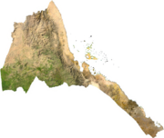
Eritrea is located in East Africa, more specifically 'Horn of Africa' and is bordered on the northeast and east by the Red Sea. The country is virtually bisected by one of the world's longest mountain ranges, the Great Rift Valley, with fertile lands to the west and the descent to desert in the East. Off the sandy and arid coastline is situated the Dahlak Archipelago and its fishing grounds. The land to the south, in the highlands, is slightly less dry and cooler. Eritrea at the southern end of the Red Sea is the home of the fork in the rift.
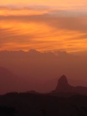
The Afar Triangle or Danakil Depression of Eritrea is the probable location of a triple junction where three tectonic plates are pulling away from one another: the Arabian Plate, and the two parts of the African Plate (the Nubian and the Somalian) splitting along the East African Rift Zone (USGS). The highest point of the country, Amba Soira, is located in the centre of Eritrea, at 3,018 metres (9,902 ft) above sea level.
The main cities of the country are the capital city of Asmara and the port town of Assab in the southeast, as well as the towns of Massawa to the east, and Keren to the north.
Economy
Since independence from Ethiopia, Eritrea has faced economic problems characteristic of a small, poor country. Like the economies of many other African nations, the economy is largely based on subsistence agriculture, with 80% of the population involved in farming and herding. Natural disasters regularly created hardships for Eritrean agriculture. The most devastating of these are locust plagues, African armyworm plagues and drought .
The Eritrean-Ethiopian War severely hurt Eritrea's economy. GDP growth in 1999 fell to less than 1%, and GDP decreased by 8.2% in 2000. The May 2000 Ethiopian offensive into southern Eritrea caused some $600 million in property damage and loss, including losses of $225 million in livestock and 55,000 homes. The attack prevented planting of crops in Eritrea's most productive region, causing food production to drop by over 60%.
Even during the war, Eritrea developed its transportation infrastructure, asphalting new roads, improving its ports, and repairing war-damaged roads and bridges as a part of the Warsay Yika'alo Program. The most remarkable of these projects has been the building of a coastal highway of more than 500 Kms connecting Massawa with Assab as well as the rehabilitation of the Eritrean Railway. The rail line now runs between the Port of Massawa and the capital Asmara. This feat of re-engineering was accomplished by local labor and ingenuity.
Eritrea's economic future remains mixed. The cessation of Ethiopian trade, which mainly used Eritrean ports before the war, leaves Eritrea with a large economic hole to fill. Eritrea's economic future depends upon its ability to master fundamental social problems like illiteracy, unemployment, and low skills, as well as the willingness to open its economy further to private enterprise so that the Diaspora's money and expertise can foster economic growth.
Society
Demographics
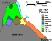
Eritrean society is ethnically heterogeneous. The largest ethnic group are the Tigrinya who compose up to 50% of the population, while the Tigre people make up another 31.4%. The rest of the population is comprised of the smaller populations of the Saho, Nara, Hedareb, Beja, Afar, Bilen, Kunama, and the Rashaida. Each nationality speaks a different native tongue, but typically, many of the minorities speak more than one language. The Jebertis are Muslim Tigrinyas who consider themselves a separate ethnicity, however, in Eritrea ethnicity is determined by language and so they are not officially recognized as separate from the Tigrinya.
There exist minorities of Italians and Ethiopian Tigrayans. Neither is generally given citizenship unless through marriage or having it conferred upon them by the State.
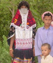
The most recent addition to the nationalities of Eritrea is the Rashaida. The Rashaida came to Eritrea in the 19th century from the Arabian Coast. The Rashaida do not typically intermarry, are typically nomadic, and number approximately 61,000, less than 1% of the population.
The Kunama are one of the earliest settled peoples in Eritrea. They adopted rain-fed agriculture and settled into communal villages in the 'lowlands' of Eritrea.
Between 900 and 500 BC Eritrea experienced massive migrations and cultural contacts from Saba in Southern Arabia. The Sabean area in Eritrea is mainly to be found in the Kebessa highlands surrounding the capital Asmara and extending southwards. There the Sabeans found the same geographical conditions as in their native Saba, suitable to terracing and their pre-existing agricultural modes of production.
Languages
Many languages are spoken in Eritrea today. The two language families that most of the languages stem from are the Semitic and Cushitic families. The Semitic languages in Eritrea are Arabic (spoken natively by the Rashaida Arabs), Tigrinya, Tigre, and the newly recognized Dahlik; these languages (primarily Tigrinya and Tigre) are spoken as a first language by over 80% of the population. The Cushitic languages in Eritrea are just as numerous, including Afar, Beja, Blin, and Saho. Kunama and Nara are also spoken in Eritrea and belong to the Nilo-Saharan language family. English and Amharic are spoken to a degree by more educated Eritreans, and there are still some speakers of Italian leftover from colonial times.
The local Tigrinya and the wider Arabic language are the two predominant languages for official purposes, but a few Italian speakers can still be found. Along with Arabic (spoken natively only by the Rashaida), English is the most widely spoken non-African language.
Education
There are five levels of education in Eritrea, pre-primary, primary, middle, secondary and post-secondary. There are nearly 238,000 students in the primary, middle, and secondary levels of education. There are approximately 824 schools in Eritrea and two Universities (University of Asmara and the Institute of Science and Technology) as well as several smaller colleges and technical schools.
One of the most important goals of Eritrea's educational policy is to provide basic education in each of Eritrea's mother tongues, as well as to develop a self-motivated and conscientious population to fight poverty and disease. Furthermore it is tooled to produce a society that is equipped with the necessary skills to function with a culture of self-reliance in the modern economy.
The education system in Eritrea is also designed to promote private sector schooling, equal access for all groups (i.e., prevent gender discrimination, prevent ethnic discrimination, prevent class discrimination, etc.) and promote continuing education, both formally and informally.
Barriers to education in Eritrea include traditional taboos, school fees (for registration and materials), and the opportunity costs of low-income households.
Religion
Eritrea has two dominant religions, Christianity and Islam, which each account for roughly half the population. The Christians consist primarily of the Eritrean Orthodox Tewahdo Church, which is the local Oriental Orthodox church, but small groups of Roman Catholics, Protestants, and other denominations also exist, while the Muslims predominantly follow Sunni Islam.
Members of the Eritrean Orthodox Church are sometimes described as Coptic Christians because it was formerly part of the Ethiopian Orthodox Tewahedo Church, which was until 1959 subject to the Coptic Pope. However, the word Coptic in modern usage refers primarily to the Egyptian Orthodox branch of Christianity. The Eritrean and Ethiopian Orthodox churches are still in full communion with the Coptic Church in Egypt. The Eritrean Orthodox Church was granted autocephaly in 1993 by the Ethiopian Orthodox Church when Eritrea became independent, and, in 1998 the Archbishop of Asmara, the capital, was elevated to the rank of patriarchate.
Since May 2002, the government of Eritrea has only officially recognized the Eritrean Orthodox Church, Sunni Islam, Catholicism and the Evangelical Lutheran church. All other faiths and denominations were required to undergo a registration process that was so stringent as to effectively be prohibitive. Amongst other things, the government's registration system requires religious groups to submit personal information on their membership in order to be allowed to worship. The few organisations that have met all of the registration requirements have still not received official recognition. Other faith groups like Jehovah's Witnesses, Bahai's, the Seventh-day Adventist Church and numerous Protestant denominations are not registered and cannot worship freely. They have effectively been banned, and harsh measures have been taken against their adherents. Over twenty Protestant pastors and almost 2000 church members have so far been detained indefinitely and without charge. In addition several Orthodox priests have also been detained, and the Patriarch of the Orthodox Church has been replaced by the Eritrean Orthodox Synod and placed under stringent house arrest ostensibly for objecting to government interference in church affairs.
There is also one last native Jew left in Eritrea, formerly from a community of hundreds in Asmara, whose ancestors had crossed from Aden in the late 19th century.
Geographic locale
 |
Red Sea |
 |
||
| Red Sea |
||||
Sovereign states: Algeria • Angola • Benin • Botswana • Burkina Faso • Burundi • Cameroon • Cape Verde • Central African Republic • Chad • Democratic Republic of the Congo • Republic of the Congo • Comoros • Côte d'Ivoire • Djibouti • Egypt 1 • Equatorial Guinea • Eritrea • Ethiopia • France 2 • Gabon • The Gambia • Ghana • Guinea-Bissau • Guinea • Kenya • Lesotho • Liberia • Libya • Madagascar • Malawi • Mali • Mauritania • Mauritius • Morocco • Mozambique • Namibia • Niger • Nigeria • Portugal 2 • Rwanda • Senegal • Seychelles • Sierra Leone • Somalia • South Africa • Spain 2 • Sudan • Swaziland • São Tomé and Príncipe • Tanzania • Togo • Tunisia • Uganda • Yemen 3 • Zambia • Zimbabwe
Dependencies: British Indian Ocean Territory (UK) • French Southern Territories (France) • Mayotte (France) • Réunion (France) • Saint Helena 4 (UK)
Unrecognized countries: Somaliland • Western Sahara •
1 Partly in Asia. 2 Mostly in Europe. 3 Mostly in Asia. 4 Includes the dependencies of Ascension Island and Tristan da Cunha.
Algeria • Angola • Benin • Botswana • Burkina Faso • Burundi • Cameroon • Cape Verde • Central African Republic • Chad • Comoros • Democratic Republic of the Congo • Republic of the Congo • Côte d'Ivoire • Djibouti • Egypt • Eritrea • Ethiopia • Equatorial Guinea • Gabon • The Gambia • Ghana • Guinea • Guinea-Bissau • Kenya • Lesotho • Liberia • Libya • Madagascar • Malawi • Mali • Mauritania • Mauritius • Mozambique • Namibia • Niger • Nigeria • Rwanda • São Tomé and Príncipe • Senegal • Seychelles • Sierra Leone • Somalia • South Africa • Sudan • Swaziland • Tanzania • Togo • Tunisia • Uganda • Western Sahara (SADR) • Zambia • Zimbabwe


