Rhine
2007 Schools Wikipedia Selection. Related subjects: European Geography
| Rhine River | |
|---|---|
 |
|
| Origin | Grisons, Switzerland |
| Mouth | North Sea, Hoek van Holland, the Netherlands |
| Basin countries | Switzerland, Italy, Liechtenstein, Austria, Germany, France, Luxembourg, Netherlands |
| Length | 1,320 km (820 mi) |
| Source elevation | Vorderrhein: approx. 2,600 m (8,500 ft) Hinterrhein: approx. 2,500 m (8,200 ft) |
| Avg. discharge | Basel: 1,060 m³/s (37,440 ft³/s) Strasbourg: 1,080 m³/s (38,150 ft³/s) Cologne: 2,090 m³/s (73,820 ft³/s) Dutch border: 2,260 m³/s (79,823 ft³/s) |
| Basin area | 185,000 km² (71,430 mi²) |

The River Rhine (Dutch Rijn, French Rhin, German Rhein, Italian: Reno, Romansch: Rein, ) is one of the longest and most important rivers in Europe at 1,320 kilometres (820 miles), with an average discharge of more than 2,000 cubic meters per second. The name of the Rhine comes from the Celtic Renos, literally "that which flows", from the Proto-Indo-European root *rei- ("to flow, run"), which is also the origin of the English verb "to run" and the Greek adage Πάντα ῥεῖ καὶ οὐδὲν μένει, (everything flows, nothing stands still).
The Rhine and the Danube formed most of the northern frontier of the Roman Empire, and since those days the Rhine has been a vital navigable waterway, carrying trade and goods deep inland. It has also served as a defensive feature, and been the basis for regional and international borders. The many castles and prehistoric fortifications along the Rhine testify to its importance as a waterway - river traffic could be stopped at these locations, usually for the purpose of collecting tolls, by the state controlling that portion of the river.
Geography


Switzerland
The Rhine's origins are in the Swiss Alps in the canton of Graubünden, where its two main initial tributaries are called Vorderrhein and Hinterrhein. The Vorderrhein (anterior Rhine) springs from Lake Tuma near the Oberalp Pass and passes the impressive Ruinaulta (the Swiss Grand Canyon). The Hinterrhein (posterior Rhine) starts from the Paradies glacier near the Rheinquellhorn at the southern border of Switzerland. One of the latter tributaries originates in Val di Lei in Italy. Both tributaries meet near Reichenau, still in Graubünden. From Reichenau, the Rhine flows north as the Alpenrhein passing Chur and forming the frontier with Liechtenstein and then Austria, and then emptying into Lake Constance. Emerging from Lake Constance, flowing west as the Hochrhein it passes the Rhine Falls and is joined by the Aare river which more than doubles its water discharge to an average of nearly 1,000 cubic meters per second. It forms the boundary with Germany until it turns north at the so-called Rhine knee at Basel.
Germany and France
Past Basel, as the Upper Rhine, it forms the southern part of the border between Germany and France in a wide valley, before entering Germany exclusively at Rheinstetten, near Karlsruhe.
At over 1000 kilometres in length, the Rhine is the longest river primarily within Germany. It is here that the Rhine encounters some of its main tributaries, such as the Neckar, the Main and later the Moselle, which contributes an average discharge of over 300 cubic meters per second.
Between Bingen and Bonn, the Middle Rhine flows through the Rhine Gorge, a formation created by erosion, which happened at about the same rate as an uplift in the region, leaving the river at about its original level, and the surrounding lands raised. This gorge is quite deep, and is the stretch of the river known for its many castles and vineyards. It is a UNESCO World Heritage Site (2002) and known as "the romantic Rhine" with more than 40 castles and fortresses from the Middle Ages (see links) and many lovely wine villages.
Though many industries can be found along the Rhine up into Switzerland, it is along the Lower Rhine in the Ruhr area that the bulk of them are concentrated, as the river passes the major cities of Cologne, Düsseldorf, and Duisburg. The Ruhr, which joins the Rhine at Duisburg, is surprisingly clean, given the amount of industry on its banks, and is used for drinking water. It adds another 70 cubic meters per second to the Rhine. However, other rivers from the Ruhr area, above all the Emscher, still bring a considerable degree of pollution. Approaching the Dutch border, the Rhine now has an average discharge of 2,290 cubic metres per second and an average width of more than 300 m.
The Netherlands
The Rhine then turns west and enters the Netherlands, where together with the rivers Meuse and Scheldt it forms an extensive delta. Crossing the border into the Netherlands at Spijk, close to Nijmegen and Arnhem the Rhine is at its widest, but the river then splits into three main distributaries: the Waal, Nederrijn ("Lower Rhine") and IJssel branches.
From here the situation becomes more complicated, as the name "Rhine" no longer coincides with the main flow of water. Most of the Rhine water (two thirds) flows farther west through the Waal and then via the Merwede and Nieuwe Merwede and, merging with the Meuse, through the Hollands Diep and Haringvliet estuaries into the North Sea. The Beneden Merwede branches off near Hardinxveld-Giessendam and continues as the Noord, to join the Lek near the village of Kinderdijk to form the Nieuwe Maas, then flows past Rotterdam and continues via Het Scheur and the Nieuwe Waterweg to the North Sea. The Oude Maas branches off near Dordrecht, farther down rejoining the Nieuwe Maas to form Het Scheur.
The other third portion of the water flows through the Pannerdens Kanaal and redistributes in the IJssel and Nederrijn. The IJssel branch carries one ninth of the water volume north into the IJsselmeer (a former bay), while the Nederrijn flows west parallel to the Waal and carries approximately two ninths of the flow. However, at Wijk bij Duurstede the Nederrijn changes its name and becomes the Lek. It flows farther west to rejoin the Noord into the Nieuwe Maas and to the North Sea.
The name "Rhine" from here on is used only for smaller streams farther to the north which together once formed the main river Rhine in Roman times. Though they retained the name, these streams do not carry water from the Rhine anymore, but are used for draining the surrounding land and polders. From Wijk bij Duurstede, the old north branch of the Rhine is called Kromme Rijn ("Crooked Rhine") and past Utrecht, first Leidse Rijn ("Rhine of Leiden") and then Oude Rijn ("Old Rhine"). The latter flows west into a sluice at Katwijk, where its waters can be discharged into the North Sea. This branch once formed the line along which the Upper Germanic limes were built.
Large cities
Basel, Strasbourg, Karlsruhe, Mannheim, Ludwigshafen, Wiesbaden, Mainz, Koblenz, Bonn, Cologne, Düsseldorf, Neuss, Krefeld, Duisburg, Arnhem (Nederrijn), Nijmegen (Waal), Utrecht (Kromme Rijn), Rotterdam (Nieuwe Maas).
Smaller cities
Konstanz, Schaffhausen, ..., Speyer, Worms, Bingen, Rüdesheim, Neuwied, Andernach, Bad Honnef, Königswinter, Niederkassel, Wesseling, Dormagen, Zons, Monheim, Wesel, Xanten, Emmerich, Zutphen (IJssel), Deventer (IJssel), Zwolle (IJssel), Kampen (IJssel).
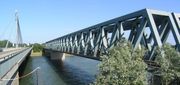
Railway bridges
Railway bridges (with nearest train station on the left and right bank):
- Switzerland
- Tens of bridges in Graubünden, too numerous to list
- Liechtenstein and Switzerland
- between Schaan and Buchs SG
- Austria and Switzerland
- between Lustenau and St. Margerethen
- Switzerland
- between Feuerthalen and Neuhausen am Rheinfall
- between Dachsen and Neuhausen am Rheinfall
- between Eglisau and Hüntwangen-Will
- Switzerland and Germany
- between Koblenz and Waldshut
- between Basel SBB and Basel Badischer Bahnhof
- France — Germany
- Strasbourg — Kehl
- Roeschwoog — Rastatt-Wintersdorf (used as street bridge since 1949, line closed 1960, rails were preserved for strategic purpose until 1999)
- Germany
 Bridge at Karlsruhe
- Karlsruhe-Maxau — Wörth am Rhein-Maximiliansau
- Germersheim — Philippsburg
- Ludwigshafen — Mannheim
- Worms
- Mainz
- Koblenz
- 2 bridges between Köln Hbf and Köln Deutz/Messe ( Hohenzollernbrücke)
- Düsseldorf
- Duisburg

- Netherlands (in the delta the river splits and its name changes often)
- between Nijmegen and Elst across Waal (Rhine delta main branch)
- between Zaltbommel and Geldermalsen across Waal, made famous in a poem by Martinus Nijhoff
- in Rotterdam across Nieuwe Maas (joint Rhine- Meuse river mouth), former bridge 'De Hef' - now replaced by a tunnel. Farther to the south, main bridge is at Moerdijk.
- between Elst and Arnhem across Nederrijn (Rhine delta second-largest branch)
- between Culemborg and Houten across Lek (Rhine delta second-largest branch farther downstream)
- at Zutphen across IJssel (Rhine third-largest branch)
- at Deventer across IJssel
- at Zwolle across IJssel
- near Alblas across Noord (a branch near Rotterdam), now being replaced by a tunnel.
- between Utrecht and Zeist across Kromme Rijn (near Bunnik station)
- At Utrecht central station across Vaartsche Rijn (canal)
- At Utrecht central station across Oude Rijn (canalised into Leidschse Rijn).
- between Utrecht and Vleuten, Woerden across Amsterdam Rijn-Canal
- between Utrecht and Breukelen,Amsterdam across Amsterdam Rijn-Canal
Tributaries

Tributaries from source to mouth:
- Left
- Thur
- Töss
- Aare (Aar)
- Birs
- Birsig
- Ill (France)
- Moder
- Lauter
- Nahe
- Moselle (Mosel)
- Nette
- Ahr
- Erft
- Meuse (Maas) (joins part of the Rhine in the shared delta)
- Right
- Hinterrhein
- Ill (Austria)
- Schussen
- Wutach
- Alb
- Wiese
- Elz
- Kinzig
- Rench
- Acher
- Murg
- Alb
- Pfinz
- Neckar
- Main
- Lahn
- Wied
- Sieg
- Wupper
- Düssel
- Ruhr
- Emscher
- Lippe
- Oude IJssel (Issel)
- Berkel
Distributaries
- IJssel
- Waal
- Lek
Canals include
- Amsterdam-Rhine Canal
- Rhine-Main-Danube Canal
- Scheldt-Rhine Canal
- Rhein-Herne Kanal which is the connection to the Mittellandkanal.
Geologic History
Alpine Orogeny
Since the Rhine flows from the Alps, a precondition of its existence is the uplifting of the Alps, which began in the Alpine Orogeny. The stage was set in the Triassic Period of the Mesozoic Era, with the opening of the Tethys Sea between the Eurasian and African plates, between about 240 MBP and 220 MBP. The Mediterranean descends from this somewhat larger Tethys sea.
At about 180 MBP, in the Jurassic Period, the two plates reversed direction and began to compress the Tethys floor, causing it to be subducted under Eurasia and pushing up the edge of the latter plate in the Alpine Orogeny of the Oligocene and Miocene Periods. Several microplates were caught in the squeeze and rotated or were pushed laterally, generating the individual features of Mediterranean geography: Iberia pushed up the Pyrenees; Italy the Alps, and Anatolia, moving west, the mountains of Greece and the islands. The compression and orogeny continue today, as shown by the ongoing raising of the mountains a small amount each year and the active volcanoes.
Just to the north of the Alpine Orogeny were highlands resulting from an earlier orogeny ( Variscan) along similar lines. These highlands helped to divert the Rhine to the west; however, the Rhine's course is set by the Rhine graben, a rift that opened in the Eocene and Oligocene periods between the western Alps and the central Alps, caused by their moving in slightly different directions. The rift does not seem to be active now.
Stream Capture
The watershed of the Rhine reaches into the Alps today, but it did not start out that way (Berendsen & Stouthamer, 2001; Fig. 2.2 ). In the Miocene period, the watershed of the Rhine reached south only to the Eifel and Westerwald hills, about 450 km north of the Alps. The Rhine then had the Sieg as a tributary, but not yet the Mosel. The northern Alps were drained by the Danube then.
Through stream capture, the Rhine extended its watershed southward. By the Pliocene period, the Rhine had captured streams down to the Vosges mountains, including the Mosel, the Main, and the Neckar. The northern Alps were drained by the Rhône then.
By the early Pleistocene period, the Rhine had captured most of its current Alpine watershed from the Rhône, including the Aare. Since that time, the Rhine has added the watershed above Lake Constance ( Vorderrhein, Hinterrhein, Alpenrhein; captured from the Rhône), the upper reaches of the Main (beyond Schweinfurt), and the Vosges mountains (captured from the Meuse) to its watershed.
Ice Age
The Pleistocene (~2.5 million years ago - 10,000 years ago) was the geological period of the Ice Ages. Since approximately 600,000 years ago six major Ice Ages have occurred, in which sea level dropped 120 m, and much of the continental margins became exposed. In the Early Pleistocene, the Rhine followed a course to the northwest, through the present North Sea. During the so-called Elsterien glaciation (~420,000 yr BP, marine oxygen isotope stage 12) the northern part of the present North Sea was blocked by the ice, and a large lake developed that overflowed through the English Channel. This caused the Rhine's course to be diverted through the English Channel. Since then, during glacial times, the river mouth was located near Brest (France), and rivers like the Thames, and Seine became tributaries to the Rhine. During interglacials, when sea level rose to approximately the present level, the Rhine built a delta in what is now called The Netherlands.
During the last Ice Age (~70,000-10,000 yr BP= Before Present), at the end of the Pleistocene, the lower Rhine flowed roughly west through the Netherlands and then to the southwest, through the English Channel, and finally to the Atlantic Ocean. The English and Irish Channels, the Baltic Sea and the North Sea were still dry land, mainly because sea level was approximately 120 m lower than today. At about 5000 BC, flooding and erosion began to open the English Channel. Most of the Rhine's current course was not under the ice during the last Ice Age, although its source must then have been a glacier. A tundra with Ice Age flora and fauna stretched across middle Europe from Asia to the Atlantic Ocean. Such was the case during the Last Glacial Maximum, ca. 22,000-14,000 yr BP, when ice covered Scandinavia and the Baltic, Britain and the Alps, but left the space between as open tundra. The loess, or wind-blown dust over that tundra settled in and around the Rhine Valley, contributing to its current agricultural usefulness.
These events were well within the residence of man. Meltwater adding to the ocean and land subsidence drowned the former coasts of Europe. The water is still rising, at the rate of about 1-3 mm per year. Further drowning is to come.
Rapid warming and change of vegetation to open forest began about 13,000 BP. By 9000 BP, Europe was fully forested. About 7000-5000 BP a general warming encouraged migration up the Danube and down the Rhine by peoples to the east, who may also have been encouraged by the sudden massive expansion of the Black Sea as the Mediterranean burst into it through the Bosphorus about 7500 BP. At least one unsuccessful search for remains of villages on the floor of the Black Sea has been conducted.
Prehistory
Palaeolithic
During the Middle Palaeolithic, ca 100,000-30,000 BP (the dates vary a geat deal) western Europe, including the Rhine and Danube Valleys, was occupied by Neanderthal Man, to which belonged the Mousterian culture of stone tools. Mousterian sites are not considered intrusive. It is believed that the Neanderthals may have evolved from the preceding Homo erectus in the vicinity of the glaciers, but the question has by no means been settled definitively.
Neanderthal sites are denser to the south, where open forest prevailed and the limestone terrain offered more caves as dwelling. The Rhine ran through an open tundra, where Neanderthals hunted big game, such as the woolly rhinoceros and the mammoth. Accordingly, open air Mousterian sites have been discovered in and around the Rhine valley.
Mesolithic
Before about 5600 BC, the Rhine Valley, along with most of Europe, was occupied by Cro-magnon man in the Mesolithic stage of cultural development; that is, they hunted and gathered, but owned a larger and more specialized tool kit than the Palaeolithic people, knew more about the plants and animals, and even may have kept a few animals.
Iron Age
During the early Iron Age, both banks of the Rhine were inhabited by Celtic tribes. However, in the beginning of the Pre-Roman Iron Age, ca 600 BC, the Proto-Germanic tribes crossed the Weser River and the Aller River, and expanded the whole distance to the banks of the Rhine. This expansion is shown archaeologically in the form of the Jastorf culture. From ca 500 BC and onwards, the lower Rhine and not the Weser and the Aller would increasingly mark the border between the Celtic tribes and the Germanic tribes.
Historic and Military Relevance
The human history of the Rhine begins with the writers of the late Roman Republic and early Roman Empire. Nearly all the classical sources mention the Rhine, and the name is always the same: Rhenus in Latin, Greek Rhenos. The Romans viewed the Rhine as the outermost border of civilization and reason, beyond which were mythical creatures and the wild Germans, not far themselves from being beasts of the wilderness they inhabited. As it was a wilderness, the Romans were eager to explore it. This view is typified by Res Gestae Divi Augusti, a long public inscription of Augustus in which he (or his ghost writer) boasts of his exploits, including sending an expeditionary fleet north of the Rhinemouth to Jutland, which no Roman had ever done (he says).
Throughout the long history of Rome, the Rhine was considered the border between Gaul or the Celts and the Germans, even though the border often was violated, as when the Germanics crossed it and joined with the Celts to form the Belgae (descending to Belgium). Typical of this point of view is a quote from Maurus Servius Honoratus, Commentary on the Aeneid of Vergil (On Book 8 Line 727):
- "(Rhenus) fluvius Galliae, qui Germanos a Gallia dividit"
- "(The Rhine is a) river of Gaul, which divides the Germanic people from Gaul."
The Rhine in the earlier sources was always a Gallic river.
As the conflict between Rome and the Germanics grew, the Romans found it necessary to station troops along the Rhine. They kept two army groups there (exercitus), the inferior, or "lower", and the superior, or "upper", which is the first distinction between upper Germania and lower Germania. It originally probably only meant upstream and downstream, the Niederrhein and Oberrhein regions of the map included with this article.
The Romans kept eight legions in five bases along the Rhine. The actual number of legions present at any base or in all depended on whether a state or threat of war existed. Between about 14 AD and 180 AD the assignment of legions was as follows.
For the army of Germania Inferior, two legions at Vetera ( Xanten): I Germanica and XX Valeria ( Pannonian troops); two legions at oppidum Ubiorum ("town of the Ubii"), which was renamed to Colonia Agrippina, descending to Cologne. The legions were V Alaudae, a Celtic legion recruited from Gallia Transalpina, and XXI, possibly a Galatian legion from the other side of the empire.
For the army of Germania superior, one legion, II Augusta, at Argentoratum ( Strasbourg), and one, XIII Gemina, at Vindonissa ( Windisch). Vespasian had commanded II Augusta before his promotion to imperator. In addition were a double legion, XIV and XVI, at Moguntiacum ( Mainz).
The two originally military districts of Germania Inferior and Germania Superior came to influence the surrounding tribes, who later respected the distinction in their alliances and confederations. For example, the upper Germans combined into the Alemanni. For a time the Rhine ceased to be a border when a union of all the west Germanics, the Franks, crossed the river and occupied Roman-dominated Celtic Gaul as far as Paris.
Subsequently language changes began to play a major political role. West Germanic dissimilated into Low Saxon-Low Franconian languages and High German languages roughly along the old lines. Perhaps it had been doing so all along. Charlemagne united all the Franks in the Holy Roman Empire, but he did not rule over a people of uniform language. After his death the empire split more or less along language lines, with the Low Franconian being spoken in the Netherlands and the Low Saxon and High German in what became Germany. The Romanized Franks became the French. The Rhine once again became a political border.
The Rhine as border has been and is a mystical and political symbol. German authors and composers have written reams about it. During World War II, it was still considered the sacred border of Germany, and was still a defensive barrier. The Germans fought especially hard to defend it. The Rhine is closely linked to many important historical events — particularly military ones — in the adjacent states. For example:
- The Battle of the Teutoburg Forest which finally established the Rhine as the northern frontier of the Roman Empire.
- It was a historic object of frontier trouble between France and Germany. Establishing France's " natural borders" on the Rhine was a long term goal of French foreign policy since the Middle Ages. French leaders such as Louis XIV and Napoleon Bonaparte tried with varying degrees of success to annex lands west of the Rhine. In 1840 the Rhine crisis evolved, because the French prime minister Adolphe Thiers started to talk about the Rhine border. In response, the nationalistic song The Watch on the Rhine (Die Wacht am Rhein) was composed at that time and during the Franco-Prussian War it rose to the status of a national anthem in Germany. The song calls for defending the Rhine against France. The song remained popular in World War I.
- At the end of World War I the Rhineland was subject to the Treaty of Versailles. This decreed that it would be occupied by the allies until 1935, and after that it would be a demilitarised zone, with the German army forbidden to enter. The Treaty of Versailles in general, and this particular provision, caused much resentment in Germany and are often cited as helping Adolf Hitler's rise to power. The allies left the Rhineland in 1930, and the German army re-occupied it in 1936, which was enormously popular in Germany. Although the allies could probably have prevented the re-occupation, Britain and France were not inclined to do so, a feature of their policy of appeasement of Hitler.
- In World War II it was recognised that the Rhine would present a formidable natural obstacle to the invasion of Germany by the western allies. The Rhine bridge at Arnhem, immortalized in the book and film "A Bridge Too Far", was a central focus of the battle for Arnhem during the failed Operation Market Garden of September 1944. The bridges at Nijmegen over the Waal distributary of the Rhine were also an objective of Market Garden. In a separate operation, the Rhine bridge at Remagen became famous when US forces were able to capture it intact - much to their own surprise - after the Germans failed to demolish it. This also became the subject of a film, The Bridge at Remagen.
- Mainz Cathedral - this more than 1,000-year-old cathedral is seat to the Bishop of Mainz. It holds significant historic value as the seat of the once politically powerful secular prince-archbishop within the Holy Roman Empire. It houses historical funerary monuments and religious artifacts.
- Das Rheingold - The Rhine is one of the settings for the first opera of Richard Wagner's Ring cycle. The action of the epic opens and ends underneath the Rhine, where three Rhinemaidens swim and protect a hoard of gold.
- Nibelung - Siegfried/ Sigurd, hero of the Nibelungenlied killed his dragon on the Drachenfels (Siebengebirge) "dragons rock" near Bonn