Image:Map of Izu Islands.png
From Wikipedia, the free encyclopedia
- Image
- File history
- File links
No higher resolution available.
Map_of_Izu_Islands.png (300 × 400 pixel, file size: 32 KB, MIME type: image/png)
|
|
This is a file from the Wikimedia Commons. The description on its description page there is shown below. |
|
|
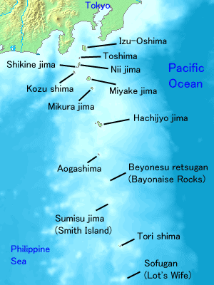
Map of Izu Islands. Created with DEMIS World Map Server.
 |
This image is in the public domain because came from the site http://www.demis.nl/wms/mapclip.htm and was released by the copyright holder. Permission is granted to copy, distribute and/or modify this map since it is based on free of copyright images from: www.demis.nl. See also approval email on de.wp. |
File links
The following pages on the English Wikipedia link to this file (pages on other projects are not listed):
- Tokyo
- Izu Islands
- Niijima, Tokyo
- Miyakejima
- Hachijojima
- Izu Oshima
- Toshima Island