Image:US population map.png
From Wikipedia, the free encyclopedia
- Image
- File history
- File links

Size of this preview: 783 × 600 pixel
Image in higher resolution (1000 × 766 pixel, file size: 116 KB, MIME type: image/png)
|
|
This is a file from the Wikimedia Commons. The description on its description page there is shown below. |
|
|
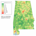
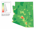
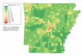
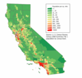
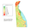
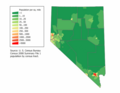
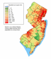
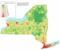
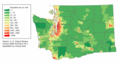
| Description | Summaryen:Category:U.S. State Population Maps en:Category:United States maps United States population density map based on Census 2000 data. See the data lineage for a process description. Also see:
|
||||||||||||||||||||||||||||||||||||||||||||||||||
|---|---|---|---|---|---|---|---|---|---|---|---|---|---|---|---|---|---|---|---|---|---|---|---|---|---|---|---|---|---|---|---|---|---|---|---|---|---|---|---|---|---|---|---|---|---|---|---|---|---|---|---|
| Source | |||||||||||||||||||||||||||||||||||||||||||||||||||
| Date | |||||||||||||||||||||||||||||||||||||||||||||||||||
| Author |
User JimIrwin on en.wikipedia |
||||||||||||||||||||||||||||||||||||||||||||||||||
| Permission |
|
||||||||||||||||||||||||||||||||||||||||||||||||||
| Other versions |
Originally from en.wikipedia; description page is (was) here * 22:21, 20 March 2006 [[:en:User:JimIrwin|JimIrwin]] 1000×766 (119,253 bytes) <span class="comment">([[:en:Category:U.S. State Population Maps]] [[:en:Category:United States maps]] United States population density map based on Census 2000 data. See the [[:en:data lineage]] for a process description. )</span> |


(Uploaded using CommonsHelper or PushForCommons)
File links
- User:JimIrwin